
Dr. Arvind Kumar*

Across the world, the understanding of disaster risk is undergoing a fundamental transformation. Hazards are no longer viewed as isolated natural events but as interconnected risks. The United Nations Office for Disaster Risk Reduction has increasingly called for “risk-informed development”, arguing that disaster-risk considerations must be embedded across sectors, investment decisions and policy processes rather than treated as a separate emergency-management concern. India has built substantial capabilities in disaster forecasting, early warning, risk mapping and institutional preparedness, but the next stage of resilience lies in connecting this knowledge to the decisions that shape development itself. From urban flooding and unsafe construction to Himalayan landslides, cyclones, heatwaves, groundwater stress and ecological degradation, seemingly different risks increasingly reveal a common reality: vulnerability is produced across interconnected systems, and therefore cannot be managed effectively through fragmented responses.
The scale of the problem is already visible in the data. The India Meteorological Department’s assessment of 2025 recorded approximately 2,760 deaths from extreme weather events across India. More than 1,370 were associated with heavy rainfall, floods, cloudbursts and landslides, while more than 1,310 were attributed to thunderstorms and lightning. These are not isolated incidents concentrated in one geography or one hazard category; they demonstrate a nationwide exposure to compound and geographically diverse risk.
The climatic baseline is changing simultaneously. IMD reported that 2025 was India’s eighth warmest year since 1901. More significantly, the decade 2016–2025 was the warmest decade on record since 1901. India’s 2025 rainfall was 110% of the 1971–2020 long-period average, while May received 126.7 mm of rainfall, the highest May rainfall recorded nationally since 1901. At the same time, some regions experienced extremely wet conditions while others experienced severe dryness. This combination matters because resilience cannot be designed around a single national average. India increasingly has to govern simultaneous excess and scarcity.
Where Risk Meets Reality
The cyclonic record provides another illustration. Four cyclonic storms formed over the North Indian Ocean in 2025, while 11 depressions, including three deep depressions, developed against a climatological annual average of about six. The lesson is not that India is necessarily experiencing more disasters every year. Rather, the risk environment is becoming more complicated because individual weather systems can generate cascading consequences across flooding, landslides, transport, agriculture, power, water supply and public health.
India’s challenge therefore begins with a basic distinction: a hazard is not automatically a disaster. An earthquake is geological; an unsafe building converts it into a human catastrophe. Rainfall is natural; construction over drainage channels and wetlands can transform it into urban flooding. A landslide may be triggered by rainfall, but slope cutting, deforestation and poorly designed infrastructure can increase exposure. Heat is meteorological, but mortality depends on housing, water availability, electricity, healthcare, occupational exposure and urban design. Disaster risk is therefore produced at the intersection of hazard, exposure, vulnerability and governance.
India has made significant progress in the first component of that equation: identifying hazards. The National Disaster Management Authority’s SACHET platform now provides geo-targeted, multilingual alerts covering hazards ranging from cyclones, floods and earthquakes to landslides, heatwaves and forest fires. The National Disaster Management Information System explicitly identifies mainstreaming disaster-risk reduction into development sectors and ensuring Build Back Better reconstruction as national priorities. The architecture for anticipation is therefore increasingly sophisticated. The unresolved question is whether anticipation is actually changing the physical decisions that create exposure.
The problem becomes even larger when natural infrastructure is considered. India’s wetlands, floodplains, forests, lakes and watersheds are often classified primarily as environmental resources, even though they perform essential disaster-management functions. Destroying these systems does not eliminate the services they provide; it transfers those services to increasingly expensive engineered infrastructure. Water makes the interconnection even clearer: India’s 2025 groundwater assessment underscores how recharge, extraction, agriculture, land use, rainfall and urbanisation are inseparable, while the Himalayan region illustrates how accelerating glacier loss and nearly 200 high-risk glacial lakes. The answer therefore lies in integrated water governance linking groundwater, rivers, ecosystems, cryosphere monitoring, land-use planning, infrastructure, early warning and community resilience.
India’s coast presents a similar systems challenge. Cyclones interact with storm surge, coastal erosion, mangroves, wetlands, ports, fisheries, industrial corridors, tourism and densely populated settlements. The economic consequences can propagate far beyond the location of landfall. Munich Re estimated that natural disasters across the Asia-Pacific region caused approximately US$73 billion in losses in 2025, above the ten-year average of US$66 billion. Only about US$9 billion was insured. Cyclone Ditwah alone generated approximately US$4 billion in losses, with less than US$0.5 billion insured. The numbers reveal another dimension of resilience: physical vulnerability and financial vulnerability reinforce one another. When losses are overwhelmingly uninsured, disaster recovery ultimately places greater pressure on households, businesses and public finances.
Governing Risk Across Systems
The World Bank’s study for India’s Sixteenth Finance Commission highlights how floods, droughts, cyclones, landslides and heatwaves affect nearly every State and Union Territory, underscoring the rising fiscal cost of disasters and shifting prevention from an emergency expenditure to a form of risk-reduction capital. Safe buildings, restored wetlands, resilient infrastructure, functional drainage, early-warning systems and climate-resilient water supplies are investments that can reduce future reconstruction costs, livelihood losses and productivity shocks. Yet the deeper challenge is institutional fragmentation: India possesses a wide network of agencies covering disaster management, weather, water, groundwater, geology, forests, health, infrastructure and urban planning, but disasters cut across these administrative boundaries. Rivers cross jurisdictions, groundwater moves beneath districts, heat affects entire urban regions, and a single cyclone or landslide can simultaneously disrupt agriculture, electricity, transport, water, health, communications and livelihoods. The imperative, therefore, is not simply stronger institutions, but stronger coordination and transversality between them.
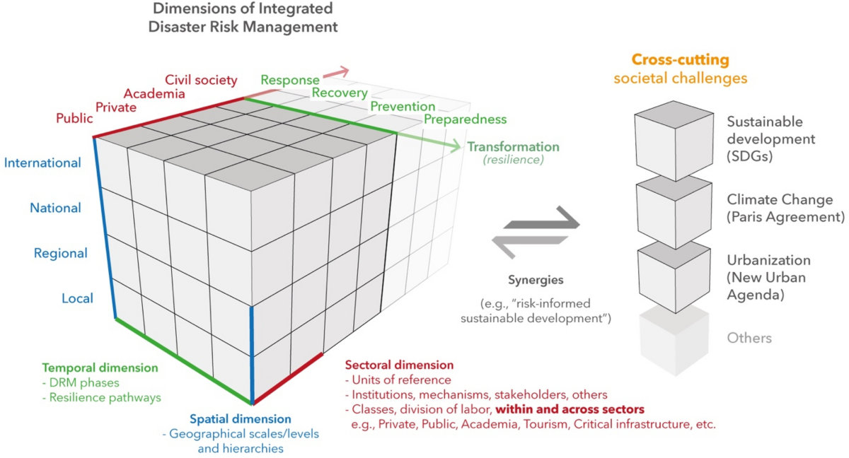
This is why transversality must become an operating principle of disaster governance. A road should not be assessed merely as a transport project if it alters slope stability or drainage. A housing project should not be evaluated merely for floor area and building compliance if it increases flood exposure, heat stress or groundwater demand. A wetland should not be treated merely as an ecological parcel if it is performing flood-storage functions. A forest should not be treated merely as green cover if it protects watersheds and stabilises slopes. A river should not be managed solely as a channel if it is simultaneously a water source, ecological system, flood pathway and livelihood base.
Way Forward
The next institutional leap for India should be the creation of a genuinely integrated national risk architecture in which risk maps, satellite data, weather forecasts, groundwater assessments, seismic information, flood maps, ecological inventories and infrastructure databases converge into decision-support systems used before projects are approved. Major roads, industrial corridors, housing developments, dams, urban expansions and tourism projects should be assessed simultaneously against multiple hazards and ecological constraints, shifting the question from merely “Is this project compliant?” to “What additional risk does this project create, transfer or reduce?”
India is increasingly capable of predicting hazards; its next leap must be to become equally capable of acting on those predictions, moving from reaction to prevention, departmental silos to transversality, compliance to accountability, and viewing ecosystems not as environmental amenities but as critical resilience infrastructure. The real question is no longer whether India has notified the risks, but whether governance will notice them early enough to change the decisions that create vulnerability.
*Editor, Focus Global Reporter